Mon-fri: 9:00-19:00
English
Afrikaans formal
Afrikaans informal
Arabic
Azerbaijan
Brazilian
Bulgarian
Catalan
Chinese simplified
Chinese traditional
Croatian
Czech
Danish
Dutch
English
Estonian
Finnish
French
Georgian
German
Greek
Hebrew
Hungarian
Icelandic
Indonesian
Italian
Japanese
Latvian
Lithuanian
Malaysian
Norwegian
Persian
Polish
Portuguese
Romanian
Russian
Serbian
Slovakian
Slovenian
Spanish
Swedish
Thai
Turkish
Ukrainian
Vietnamese
Sign Up
Login
Files
Stock
Photo
Video
Audio
Vector
Offer
Lightboxes
Items
Most downloaded
Featured
Most popular
New
Free
Prints and Products
Canvas Prints
Framed Prints
Prints and Posters
Metal Prints
Acrylic Prints
Pillows
Duvet Covers
Shower Curtain
Categories
Portrait Sessions
Site info
About
Your Shopping Cart is empty.
Files
Stock
Photo
Video
Audio
Vector
Offer
Lightboxes
Items
Most downloaded
Featured
Most popular
New
Free
Prints and Products
Canvas Prints
Framed Prints
Prints and Posters
Metal Prints
Acrylic Prints
Pillows
Duvet Covers
Shower Curtain
Categories
Portrait Sessions
Site info
About
Home
Catalog
Download sample
File Details
Published:
2022-07-03 20:22:12.674595
Category:
Travel
Type:
Vector
Model release:
Yes
Share
The Caribbean, colored political map. Subregion of the Americas in the Caribbean Sea with its islands and English names. The Greater Antilles and the Lesser Antilles. Isolated illustration over white.
Contributor:
Peter Hermes Furian
ID : 514824685
Files
Prints and Products
Title
Filesize
Vector
9000x6000
Buy on Adobe Stock
Title
Price
Buy
Wall Art
Canvas Prints
$30.00
Framed Prints
$10.00
Prints and Posters
$5.00
Metal Prints
$10.00
Acrylic Prints
$10.00
Home Decor
Pillows
$18.00
Duvet Covers
$100.00
Shower Curtain
$50.00
Order print
Keywords
caribbean
,
caribbean sea
,
america
,
antilles
,
map
,
greater
,
island
,
lesser
,
cuba
,
jamaica
,
haiti
,
bahamas
,
dominican republic
,
puerto rico
,
virgin islands
,
america
,
windward
,
west
,
indie
,
west indies
,
south america
,
country
,
venezuela
,
colombia
,
colours
,
english
,
cruise
,
destination
,
land
,
state
,
atlas
,
nation
,
cartography
,
geography
,
political
,
tropical
,
mapping
,
overview
,
travel
,
infographic
,
illustration
,
white background
Related items
 English
 Afrikaans formal
 Arabic
 Azerbaijan
 Brazilian
 Bulgarian
 Catalan
 Chinese simplified
 Croatian
 Czech
Czech Danish
 Dutch
Dutch Estonian
 Finnish
 French
 Georgian
 German
 Greek
Greek Hebrew
 Hungarian
 Icelandic
 Indonesian
 Italian
 Japanese
 Latvian
 Lithuanian
 Malaysian
 Norwegian
 Persian
 Polish
 Portuguese
 Romanian
 Russian
 Serbian
 Slovakian
 Slovenian
 Spanish
 Swedish
 Thai
Thai Turkish
 Ukrainian
 Vietnamese
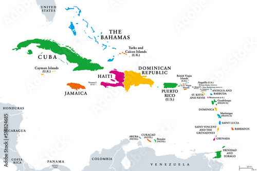
)